
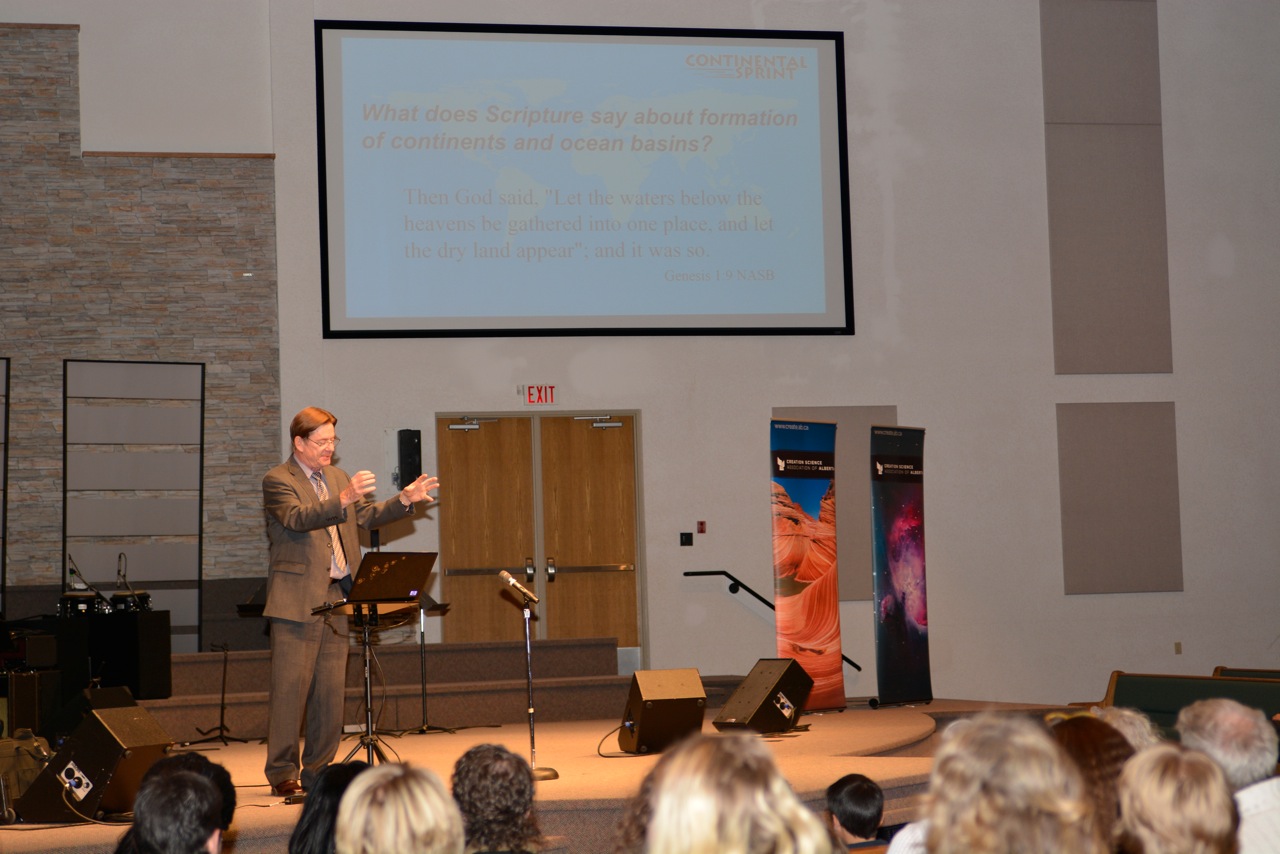
People came from hundreds of kilometres away to hear Dr. Steven Ausin speak at CSAA’s Creation Weekend in Edmonton in October. His first lecture on Friday evening, October 24 was on the global flood model, also known as catastrophic plate tectonics. This model provides an explanation for how the earth came to its present state (as a result of a worldwide flood). The model was first proposed in a paper in 1994. There were six authors, Drs. Steven Austin, John Baumgardner, Hubert Humphreys, Andrew Snelling, Larry Vardiman and Kurt Wise (each representing different relevant technical areas of expertise).
Global Flood Model
The idea that originally there was just one connected land mass on earth, was first proposed by Antonio Snider in the 19th century. He lived in the U.S. but he could not find a publisher there for his book Creation Mysteries Revealed. So he published it in French in France (1859). The book was universally ignored. Then in 1910 European Alfred Wegner published a book on the similar idea of “continental drift”, but it was vilified by geologists for 50 years.
Geological opinion changed however in the late 1960s. The new science was now called “plate tectonics.” Later a Ph.D. student at UCLA developed a 3-D computer model which simulated the motions of earth’s mantle. The model theoretically divided the globe up into tiny icosahedral components. For each component, the Cray supercomputer at the university calculated temperature, pressure, density, viscosity and velocity. As conditions changed at any location, the computer calculated co-responding changes everywhere else. Dr. Baumgardner graduated from UCLA in 1983 and was shortly appointed scientist at Los Alamos National Laboratory. His model was then put to good use in the supercomputers at the national laboratory. The interesting thing is that the model, when run at a high speed, is useful for understanding how the continents separated and the whole earth was inundated during the flood of Noah.
Dr. Austin reviewed the mineral content of crustal and mantle rocks which could make the catastrophic plate tectonics happen. The original ocean floor sank into the mantle, causing friction and churning within the mantle, so that the continents were ripped apart. A new hotter ocean floor expanded upwards driving ocean waters and sea bottom sediments over the continents. Later the new ocean floor cooled and sank so that the waters then rushed off the land back into the sea.
Dr. Austin also discussed numerous examples of geological phenomena that fit the model. For example he noted the Sauk sequence, Cambrian sandstone which nestles around and partly buries the Canadian shield. The latter is a granite type rock in a giant horseshoe pattern which surrounds Hudson’s Bay. The sandstone extends from the Arctic in the west, to the southern US (Tapeats sandstone in Arizona) and up into Quebec in the east.
Day of the Cross
On Saturday morning Dr. Austin discussed five signs of the day of the cross. He first discussed the date of these events concluding that it was April 3, AD 33. The events included three hours of darkness beginning at noon, the temple veil torn, an earthquake, a lunar eclipse and Jesus dying on the cross. The prophet Amos had foretold the darkness and earthquake (ch. 8: 8 , 9). Nobody knows what caused the darkness. It was not a solar eclipse because the full moon was on the wrong side of the earth, and the darkness lasted three hours instead of 7 minutes that a typical solar eclipse lasts.Then at 3:20 pm the moon entered earth’s shadow. At 6:20 pm on that day, the moon rose in partial eclipse and it was red. This was foretold by the prophet Joel, Dr. Austin said, in chapter 2:30,31 and the apostle Peter referred to these events in Acts 2: 19 and 20. Apparently there is software available from NASA with which one can calculate the date of that eclipse (see//eclipse.qsfc.nasa eclipse). In similar fashion Dr. Austin discussed the other signs on his list.
Grand Canyon
The third lecture dealt with what we see at Grand Canyon and what these details suggest. The deep layers of sedimentary rock, he said, were deposited quickly. A number of studies have demonstrated for example that the cross bedded deposits in the Navajo, Coconino and Tapeats sandstones were formed under deep water moving at catastrophic rates of 1-3 m/second. Such a phenomenon is observed today only in very narrow water channels, not over a huge territory such as this. Similarly he discussed the Redwall limestone with a 320 km long bed of nautiloid fossils (on average 1 fossil/m2). It appears that the squid-like animals were entombed by a wave of sediment sweeping into the area at a rate of about 7 m/second. These animals did not stand a chance!
In connection with the rocks of Grand Canyon, Dr. Austin also discussed evidence for major earthquakes including uplift of the plateau; erosion (such as sheet erosion as the flood waters retreated); volcanoes on the upper rim (which lend themselves to radiometric dating studies); and an exponential decline in all these phenomena since the time of the flood.
Jerusalem Earthquake of AD 33
The record of past earthquakes in the vicinity of Jerusalem is preserved in the muddy sediments of the Dead Sea. Each year the sediments falling to the sea bottom during summer are a different colour from those in the winter. Each couplet lies smoothly on top of the preceeding deposit unless an earthquake occurs. The more extreme are the ripples or folding at a given level, the stronger and closer was the earthquake at the time those sediments were being laid down. The retreating waters of the Dead Sea in recent years means that deep deposits are now exposed that can be studied. A lengthy record of earthquakes in the Holy Land is now available for study.
The record in the sediments obviously needs a clear benchmark from which to figure out other events. The largest quake in the area during the last 2700 years was the event of 31 BC which was described by Josephus. It must have been about magnitude 7 because it ruptured 110 km along the Jericho fault with a vertical displacement of 3.5 m along the fault. There is no mistaking the resulting contortions in the Dead Sea sediments.
Another major earthquake occurred in 110 AD. Counting the layers between these major disturbances, one comes to the disturbance of AD 33 which was greatest at the northern end of the Dead Sea, only 64 km south of Jerusalem. From the pattern of disturbance, Dr. Austin estimates that the magnitude was about 6. The Bible describes 3 earthquakes that year, the one on Good Friday, the one on Easter Sunday, and one during the summer, described in Acts 4:31.
The beauty of the Dead Sea sediments is that nothing except earthquakes disturbs the smooth appearance of the thin layers. Nothing lives in these salty bottom sediments, so there are no creatures to disturb the tranquility of the deposits. Dr. Austin’s research is ongoing, and with local collaborators in Jordan, he hopes to study more earthquakes mentioned in the Bible such as the one mentioned in Amos 1:1 which occurred about 8 centuries prior to the time of Christ.
Dr. Austin’s lectures illustrate so well how exciting it is to be a Christian geologist with such a wide variety of topics to study. There has been little interest for example from other scientists in studying the Dead Sea sediments, because other people are not asking the questions that Dr. Austin is asking. Now is the time for many young people to become qualified to continue these fascinating fields of study.
February 2015
Subscribe to Dialogue
FEATURED BOOKS AND DVDS
Hardcover / $18.00 / 125 Pages / full colour
People came from hundreds of kilometres away to hear Dr. Steven Ausin speak at CSAA’s Creation Weekend in Edmonton in October. His first lecture on Friday evening, October 24 was on the global flood model, also known as catastrophic plate tectonics. This model provides an explanation for how the earth came to its present state (as a result of a worldwide flood). The model was first proposed in a paper in 1994. There were six authors, Drs. Steven Austin, John Baumgardner, Hubert Humphreys, Andrew Snelling, Larry Vardiman and Kurt Wise (each representing different relevant technical areas of expertise).
Global Flood Model
The idea that originally there was just one connected land mass on earth, was first proposed by Antonio Snider in the 19th century. He lived in the U.S. but he could not find a publisher there for his book Creation Mysteries Revealed. So he published it in French in France (1859). The book was universally ignored. Then in 1910 European Alfred Wegner published a book on the similar idea of “continental drift”, but it was vilified by geologists for 50 years.
Geological opinion changed however in the late 1960s. The new science was now called “plate tectonics.” Later a Ph.D. student at UCLA developed a 3-D computer model which simulated the motions of earth’s mantle. The model theoretically divided the globe up into tiny icosahedral components. For each component, the Cray supercomputer at the university calculated temperature, pressure, density, viscosity and velocity. As conditions changed at any location, the computer calculated co-responding changes everywhere else. Dr. Baumgardner graduated from UCLA in 1983 and was shortly appointed scientist at Los Alamos National Laboratory. His model was then put to good use in the supercomputers at the national laboratory. The interesting thing is that the model, when run at a high speed, is useful for understanding how the continents separated and the whole earth was inundated during the flood of Noah.
Dr. Austin reviewed the mineral content of crustal and mantle rocks which could make the catastrophic plate tectonics happen. The original ocean floor sank into the mantle, causing friction and churning within the mantle, so that the continents were ripped apart. A new hotter ocean floor expanded upwards driving ocean waters and sea bottom sediments over the continents. Later the new ocean floor cooled and sank so that the waters then rushed off the land back into the sea.
Dr. Austin also discussed numerous examples of geological phenomena that fit the model. For example he noted the Sauk sequence, Cambrian sandstone which nestles around and partly buries the Canadian shield. The latter is a granite type rock in a giant horseshoe pattern which surrounds Hudson’s Bay. The sandstone extends from the Arctic in the west, to the southern US (Tapeats sandstone in Arizona) and up into Quebec in the east.
Day of the Cross
On Saturday morning Dr. Austin discussed five signs of the day of the cross. He first discussed the date of these events concluding that it was April 3, AD 33. The events included three hours of darkness beginning at noon, the temple veil torn, an earthquake, a lunar eclipse and Jesus dying on the cross. The prophet Amos had foretold the darkness and earthquake (ch. 8: 8 , 9). Nobody knows what caused the darkness. It was not a solar eclipse because the full moon was on the wrong side of the earth, and the darkness lasted three hours instead of 7 minutes that a typical solar eclipse lasts.Then at 3:20 pm the moon entered earth’s shadow. At 6:20 pm on that day, the moon rose in partial eclipse and it was red. This was foretold by the prophet Joel, Dr. Austin said, in chapter 2:30,31 and the apostle Peter referred to these events in Acts 2: 19 and 20. Apparently there is software available from NASA with which one can calculate the date of that eclipse (see//eclipse.qsfc.nasa eclipse). In similar fashion Dr. Austin discussed the other signs on his list.
Grand Canyon
The third lecture dealt with what we see at Grand Canyon and what these details suggest. The deep layers of sedimentary rock, he said, were deposited quickly. A number of studies have demonstrated for example that the cross bedded deposits in the Navajo, Coconino and Tapeats sandstones were formed under deep water moving at catastrophic rates of 1-3 m/second. Such a phenomenon is observed today only in very narrow water channels, not over a huge territory such as this. Similarly he discussed the Redwall limestone with a 320 km long bed of nautiloid fossils (on average 1 fossil/m2). It appears that the squid-like animals were entombed by a wave of sediment sweeping into the area at a rate of about 7 m/second. These animals did not stand a chance!
In connection with the rocks of Grand Canyon, Dr. Austin also discussed evidence for major earthquakes including uplift of the plateau; erosion (such as sheet erosion as the flood waters retreated); volcanoes on the upper rim (which lend themselves to radiometric dating studies); and an exponential decline in all these phenomena since the time of the flood.
Jerusalem Earthquake of AD 33
The record of past earthquakes in the vicinity of Jerusalem is preserved in the muddy sediments of the Dead Sea. Each year the sediments falling to the sea bottom during summer are a different colour from those in the winter. Each couplet lies smoothly on top of the preceeding deposit unless an earthquake occurs. The more extreme are the ripples or folding at a given level, the stronger and closer was the earthquake at the time those sediments were being laid down. The retreating waters of the Dead Sea in recent years means that deep deposits are now exposed that can be studied. A lengthy record of earthquakes in the Holy Land is now available for study.
The record in the sediments obviously needs a clear benchmark from which to figure out other events. The largest quake in the area during the last 2700 years was the event of 31 BC which was described by Josephus. It must have been about magnitude 7 because it ruptured 110 km along the Jericho fault with a vertical displacement of 3.5 m along the fault. There is no mistaking the resulting contortions in the Dead Sea sediments.
Another major earthquake occurred in 110 AD. Counting the layers between these major disturbances, one comes to the disturbance of AD 33 which was greatest at the northern end of the Dead Sea, only 64 km south of Jerusalem. From the pattern of disturbance, Dr. Austin estimates that the magnitude was about 6. The Bible describes 3 earthquakes that year, the one on Good Friday, the one on Easter Sunday, and one during the summer, described in Acts 4:31.
The beauty of the Dead Sea sediments is that nothing except earthquakes disturbs the smooth appearance of the thin layers. Nothing lives in these salty bottom sediments, so there are no creatures to disturb the tranquility of the deposits. Dr. Austin’s research is ongoing, and with local collaborators in Jordan, he hopes to study more earthquakes mentioned in the Bible such as the one mentioned in Amos 1:1 which occurred about 8 centuries prior to the time of Christ.
Dr. Austin’s lectures illustrate so well how exciting it is to be a Christian geologist with such a wide variety of topics to study. There has been little interest for example from other scientists in studying the Dead Sea sediments, because other people are not asking the questions that Dr. Austin is asking. Now is the time for many young people to become qualified to continue these fascinating fields of study.
Order Online
Paperback / $6.00 / 64 Pages / Full colour
People came from hundreds of kilometres away to hear Dr. Steven Ausin speak at CSAA’s Creation Weekend in Edmonton in October. His first lecture on Friday evening, October 24 was on the global flood model, also known as catastrophic plate tectonics. This model provides an explanation for how the earth came to its present state (as a result of a worldwide flood). The model was first proposed in a paper in 1994. There were six authors, Drs. Steven Austin, John Baumgardner, Hubert Humphreys, Andrew Snelling, Larry Vardiman and Kurt Wise (each representing different relevant technical areas of expertise).
Global Flood Model
The idea that originally there was just one connected land mass on earth, was first proposed by Antonio Snider in the 19th century. He lived in the U.S. but he could not find a publisher there for his book Creation Mysteries Revealed. So he published it in French in France (1859). The book was universally ignored. Then in 1910 European Alfred Wegner published a book on the similar idea of “continental drift”, but it was vilified by geologists for 50 years.
Geological opinion changed however in the late 1960s. The new science was now called “plate tectonics.” Later a Ph.D. student at UCLA developed a 3-D computer model which simulated the motions of earth’s mantle. The model theoretically divided the globe up into tiny icosahedral components. For each component, the Cray supercomputer at the university calculated temperature, pressure, density, viscosity and velocity. As conditions changed at any location, the computer calculated co-responding changes everywhere else. Dr. Baumgardner graduated from UCLA in 1983 and was shortly appointed scientist at Los Alamos National Laboratory. His model was then put to good use in the supercomputers at the national laboratory. The interesting thing is that the model, when run at a high speed, is useful for understanding how the continents separated and the whole earth was inundated during the flood of Noah.
Dr. Austin reviewed the mineral content of crustal and mantle rocks which could make the catastrophic plate tectonics happen. The original ocean floor sank into the mantle, causing friction and churning within the mantle, so that the continents were ripped apart. A new hotter ocean floor expanded upwards driving ocean waters and sea bottom sediments over the continents. Later the new ocean floor cooled and sank so that the waters then rushed off the land back into the sea.
Dr. Austin also discussed numerous examples of geological phenomena that fit the model. For example he noted the Sauk sequence, Cambrian sandstone which nestles around and partly buries the Canadian shield. The latter is a granite type rock in a giant horseshoe pattern which surrounds Hudson’s Bay. The sandstone extends from the Arctic in the west, to the southern US (Tapeats sandstone in Arizona) and up into Quebec in the east.
Day of the Cross
On Saturday morning Dr. Austin discussed five signs of the day of the cross. He first discussed the date of these events concluding that it was April 3, AD 33. The events included three hours of darkness beginning at noon, the temple veil torn, an earthquake, a lunar eclipse and Jesus dying on the cross. The prophet Amos had foretold the darkness and earthquake (ch. 8: 8 , 9). Nobody knows what caused the darkness. It was not a solar eclipse because the full moon was on the wrong side of the earth, and the darkness lasted three hours instead of 7 minutes that a typical solar eclipse lasts.Then at 3:20 pm the moon entered earth’s shadow. At 6:20 pm on that day, the moon rose in partial eclipse and it was red. This was foretold by the prophet Joel, Dr. Austin said, in chapter 2:30,31 and the apostle Peter referred to these events in Acts 2: 19 and 20. Apparently there is software available from NASA with which one can calculate the date of that eclipse (see//eclipse.qsfc.nasa eclipse). In similar fashion Dr. Austin discussed the other signs on his list.
Grand Canyon
The third lecture dealt with what we see at Grand Canyon and what these details suggest. The deep layers of sedimentary rock, he said, were deposited quickly. A number of studies have demonstrated for example that the cross bedded deposits in the Navajo, Coconino and Tapeats sandstones were formed under deep water moving at catastrophic rates of 1-3 m/second. Such a phenomenon is observed today only in very narrow water channels, not over a huge territory such as this. Similarly he discussed the Redwall limestone with a 320 km long bed of nautiloid fossils (on average 1 fossil/m2). It appears that the squid-like animals were entombed by a wave of sediment sweeping into the area at a rate of about 7 m/second. These animals did not stand a chance!
In connection with the rocks of Grand Canyon, Dr. Austin also discussed evidence for major earthquakes including uplift of the plateau; erosion (such as sheet erosion as the flood waters retreated); volcanoes on the upper rim (which lend themselves to radiometric dating studies); and an exponential decline in all these phenomena since the time of the flood.
Jerusalem Earthquake of AD 33
The record of past earthquakes in the vicinity of Jerusalem is preserved in the muddy sediments of the Dead Sea. Each year the sediments falling to the sea bottom during summer are a different colour from those in the winter. Each couplet lies smoothly on top of the preceeding deposit unless an earthquake occurs. The more extreme are the ripples or folding at a given level, the stronger and closer was the earthquake at the time those sediments were being laid down. The retreating waters of the Dead Sea in recent years means that deep deposits are now exposed that can be studied. A lengthy record of earthquakes in the Holy Land is now available for study.
The record in the sediments obviously needs a clear benchmark from which to figure out other events. The largest quake in the area during the last 2700 years was the event of 31 BC which was described by Josephus. It must have been about magnitude 7 because it ruptured 110 km along the Jericho fault with a vertical displacement of 3.5 m along the fault. There is no mistaking the resulting contortions in the Dead Sea sediments.
Another major earthquake occurred in 110 AD. Counting the layers between these major disturbances, one comes to the disturbance of AD 33 which was greatest at the northern end of the Dead Sea, only 64 km south of Jerusalem. From the pattern of disturbance, Dr. Austin estimates that the magnitude was about 6. The Bible describes 3 earthquakes that year, the one on Good Friday, the one on Easter Sunday, and one during the summer, described in Acts 4:31.
The beauty of the Dead Sea sediments is that nothing except earthquakes disturbs the smooth appearance of the thin layers. Nothing lives in these salty bottom sediments, so there are no creatures to disturb the tranquility of the deposits. Dr. Austin’s research is ongoing, and with local collaborators in Jordan, he hopes to study more earthquakes mentioned in the Bible such as the one mentioned in Amos 1:1 which occurred about 8 centuries prior to the time of Christ.
Dr. Austin’s lectures illustrate so well how exciting it is to be a Christian geologist with such a wide variety of topics to study. There has been little interest for example from other scientists in studying the Dead Sea sediments, because other people are not asking the questions that Dr. Austin is asking. Now is the time for many young people to become qualified to continue these fascinating fields of study.
Order Online
Hardcover / $18.00 / 120 Pages / Full colour
People came from hundreds of kilometres away to hear Dr. Steven Ausin speak at CSAA’s Creation Weekend in Edmonton in October. His first lecture on Friday evening, October 24 was on the global flood model, also known as catastrophic plate tectonics. This model provides an explanation for how the earth came to its present state (as a result of a worldwide flood). The model was first proposed in a paper in 1994. There were six authors, Drs. Steven Austin, John Baumgardner, Hubert Humphreys, Andrew Snelling, Larry Vardiman and Kurt Wise (each representing different relevant technical areas of expertise).
Global Flood Model
The idea that originally there was just one connected land mass on earth, was first proposed by Antonio Snider in the 19th century. He lived in the U.S. but he could not find a publisher there for his book Creation Mysteries Revealed. So he published it in French in France (1859). The book was universally ignored. Then in 1910 European Alfred Wegner published a book on the similar idea of “continental drift”, but it was vilified by geologists for 50 years.
Geological opinion changed however in the late 1960s. The new science was now called “plate tectonics.” Later a Ph.D. student at UCLA developed a 3-D computer model which simulated the motions of earth’s mantle. The model theoretically divided the globe up into tiny icosahedral components. For each component, the Cray supercomputer at the university calculated temperature, pressure, density, viscosity and velocity. As conditions changed at any location, the computer calculated co-responding changes everywhere else. Dr. Baumgardner graduated from UCLA in 1983 and was shortly appointed scientist at Los Alamos National Laboratory. His model was then put to good use in the supercomputers at the national laboratory. The interesting thing is that the model, when run at a high speed, is useful for understanding how the continents separated and the whole earth was inundated during the flood of Noah.
Dr. Austin reviewed the mineral content of crustal and mantle rocks which could make the catastrophic plate tectonics happen. The original ocean floor sank into the mantle, causing friction and churning within the mantle, so that the continents were ripped apart. A new hotter ocean floor expanded upwards driving ocean waters and sea bottom sediments over the continents. Later the new ocean floor cooled and sank so that the waters then rushed off the land back into the sea.
Dr. Austin also discussed numerous examples of geological phenomena that fit the model. For example he noted the Sauk sequence, Cambrian sandstone which nestles around and partly buries the Canadian shield. The latter is a granite type rock in a giant horseshoe pattern which surrounds Hudson’s Bay. The sandstone extends from the Arctic in the west, to the southern US (Tapeats sandstone in Arizona) and up into Quebec in the east.
Day of the Cross
On Saturday morning Dr. Austin discussed five signs of the day of the cross. He first discussed the date of these events concluding that it was April 3, AD 33. The events included three hours of darkness beginning at noon, the temple veil torn, an earthquake, a lunar eclipse and Jesus dying on the cross. The prophet Amos had foretold the darkness and earthquake (ch. 8: 8 , 9). Nobody knows what caused the darkness. It was not a solar eclipse because the full moon was on the wrong side of the earth, and the darkness lasted three hours instead of 7 minutes that a typical solar eclipse lasts.Then at 3:20 pm the moon entered earth’s shadow. At 6:20 pm on that day, the moon rose in partial eclipse and it was red. This was foretold by the prophet Joel, Dr. Austin said, in chapter 2:30,31 and the apostle Peter referred to these events in Acts 2: 19 and 20. Apparently there is software available from NASA with which one can calculate the date of that eclipse (see//eclipse.qsfc.nasa eclipse). In similar fashion Dr. Austin discussed the other signs on his list.
Grand Canyon
The third lecture dealt with what we see at Grand Canyon and what these details suggest. The deep layers of sedimentary rock, he said, were deposited quickly. A number of studies have demonstrated for example that the cross bedded deposits in the Navajo, Coconino and Tapeats sandstones were formed under deep water moving at catastrophic rates of 1-3 m/second. Such a phenomenon is observed today only in very narrow water channels, not over a huge territory such as this. Similarly he discussed the Redwall limestone with a 320 km long bed of nautiloid fossils (on average 1 fossil/m2). It appears that the squid-like animals were entombed by a wave of sediment sweeping into the area at a rate of about 7 m/second. These animals did not stand a chance!
In connection with the rocks of Grand Canyon, Dr. Austin also discussed evidence for major earthquakes including uplift of the plateau; erosion (such as sheet erosion as the flood waters retreated); volcanoes on the upper rim (which lend themselves to radiometric dating studies); and an exponential decline in all these phenomena since the time of the flood.
Jerusalem Earthquake of AD 33
The record of past earthquakes in the vicinity of Jerusalem is preserved in the muddy sediments of the Dead Sea. Each year the sediments falling to the sea bottom during summer are a different colour from those in the winter. Each couplet lies smoothly on top of the preceeding deposit unless an earthquake occurs. The more extreme are the ripples or folding at a given level, the stronger and closer was the earthquake at the time those sediments were being laid down. The retreating waters of the Dead Sea in recent years means that deep deposits are now exposed that can be studied. A lengthy record of earthquakes in the Holy Land is now available for study.
The record in the sediments obviously needs a clear benchmark from which to figure out other events. The largest quake in the area during the last 2700 years was the event of 31 BC which was described by Josephus. It must have been about magnitude 7 because it ruptured 110 km along the Jericho fault with a vertical displacement of 3.5 m along the fault. There is no mistaking the resulting contortions in the Dead Sea sediments.
Another major earthquake occurred in 110 AD. Counting the layers between these major disturbances, one comes to the disturbance of AD 33 which was greatest at the northern end of the Dead Sea, only 64 km south of Jerusalem. From the pattern of disturbance, Dr. Austin estimates that the magnitude was about 6. The Bible describes 3 earthquakes that year, the one on Good Friday, the one on Easter Sunday, and one during the summer, described in Acts 4:31.
The beauty of the Dead Sea sediments is that nothing except earthquakes disturbs the smooth appearance of the thin layers. Nothing lives in these salty bottom sediments, so there are no creatures to disturb the tranquility of the deposits. Dr. Austin’s research is ongoing, and with local collaborators in Jordan, he hopes to study more earthquakes mentioned in the Bible such as the one mentioned in Amos 1:1 which occurred about 8 centuries prior to the time of Christ.
Dr. Austin’s lectures illustrate so well how exciting it is to be a Christian geologist with such a wide variety of topics to study. There has been little interest for example from other scientists in studying the Dead Sea sediments, because other people are not asking the questions that Dr. Austin is asking. Now is the time for many young people to become qualified to continue these fascinating fields of study.
Order Online
Hardcover / $52.00 / 433 Pages
People came from hundreds of kilometres away to hear Dr. Steven Ausin speak at CSAA’s Creation Weekend in Edmonton in October. His first lecture on Friday evening, October 24 was on the global flood model, also known as catastrophic plate tectonics. This model provides an explanation for how the earth came to its present state (as a result of a worldwide flood). The model was first proposed in a paper in 1994. There were six authors, Drs. Steven Austin, John Baumgardner, Hubert Humphreys, Andrew Snelling, Larry Vardiman and Kurt Wise (each representing different relevant technical areas of expertise).
Global Flood Model
The idea that originally there was just one connected land mass on earth, was first proposed by Antonio Snider in the 19th century. He lived in the U.S. but he could not find a publisher there for his book Creation Mysteries Revealed. So he published it in French in France (1859). The book was universally ignored. Then in 1910 European Alfred Wegner published a book on the similar idea of “continental drift”, but it was vilified by geologists for 50 years.
Geological opinion changed however in the late 1960s. The new science was now called “plate tectonics.” Later a Ph.D. student at UCLA developed a 3-D computer model which simulated the motions of earth’s mantle. The model theoretically divided the globe up into tiny icosahedral components. For each component, the Cray supercomputer at the university calculated temperature, pressure, density, viscosity and velocity. As conditions changed at any location, the computer calculated co-responding changes everywhere else. Dr. Baumgardner graduated from UCLA in 1983 and was shortly appointed scientist at Los Alamos National Laboratory. His model was then put to good use in the supercomputers at the national laboratory. The interesting thing is that the model, when run at a high speed, is useful for understanding how the continents separated and the whole earth was inundated during the flood of Noah.
Dr. Austin reviewed the mineral content of crustal and mantle rocks which could make the catastrophic plate tectonics happen. The original ocean floor sank into the mantle, causing friction and churning within the mantle, so that the continents were ripped apart. A new hotter ocean floor expanded upwards driving ocean waters and sea bottom sediments over the continents. Later the new ocean floor cooled and sank so that the waters then rushed off the land back into the sea.
Dr. Austin also discussed numerous examples of geological phenomena that fit the model. For example he noted the Sauk sequence, Cambrian sandstone which nestles around and partly buries the Canadian shield. The latter is a granite type rock in a giant horseshoe pattern which surrounds Hudson’s Bay. The sandstone extends from the Arctic in the west, to the southern US (Tapeats sandstone in Arizona) and up into Quebec in the east.
Day of the Cross
On Saturday morning Dr. Austin discussed five signs of the day of the cross. He first discussed the date of these events concluding that it was April 3, AD 33. The events included three hours of darkness beginning at noon, the temple veil torn, an earthquake, a lunar eclipse and Jesus dying on the cross. The prophet Amos had foretold the darkness and earthquake (ch. 8: 8 , 9). Nobody knows what caused the darkness. It was not a solar eclipse because the full moon was on the wrong side of the earth, and the darkness lasted three hours instead of 7 minutes that a typical solar eclipse lasts.Then at 3:20 pm the moon entered earth’s shadow. At 6:20 pm on that day, the moon rose in partial eclipse and it was red. This was foretold by the prophet Joel, Dr. Austin said, in chapter 2:30,31 and the apostle Peter referred to these events in Acts 2: 19 and 20. Apparently there is software available from NASA with which one can calculate the date of that eclipse (see//eclipse.qsfc.nasa eclipse). In similar fashion Dr. Austin discussed the other signs on his list.
Grand Canyon
The third lecture dealt with what we see at Grand Canyon and what these details suggest. The deep layers of sedimentary rock, he said, were deposited quickly. A number of studies have demonstrated for example that the cross bedded deposits in the Navajo, Coconino and Tapeats sandstones were formed under deep water moving at catastrophic rates of 1-3 m/second. Such a phenomenon is observed today only in very narrow water channels, not over a huge territory such as this. Similarly he discussed the Redwall limestone with a 320 km long bed of nautiloid fossils (on average 1 fossil/m2). It appears that the squid-like animals were entombed by a wave of sediment sweeping into the area at a rate of about 7 m/second. These animals did not stand a chance!
In connection with the rocks of Grand Canyon, Dr. Austin also discussed evidence for major earthquakes including uplift of the plateau; erosion (such as sheet erosion as the flood waters retreated); volcanoes on the upper rim (which lend themselves to radiometric dating studies); and an exponential decline in all these phenomena since the time of the flood.
Jerusalem Earthquake of AD 33
The record of past earthquakes in the vicinity of Jerusalem is preserved in the muddy sediments of the Dead Sea. Each year the sediments falling to the sea bottom during summer are a different colour from those in the winter. Each couplet lies smoothly on top of the preceeding deposit unless an earthquake occurs. The more extreme are the ripples or folding at a given level, the stronger and closer was the earthquake at the time those sediments were being laid down. The retreating waters of the Dead Sea in recent years means that deep deposits are now exposed that can be studied. A lengthy record of earthquakes in the Holy Land is now available for study.
The record in the sediments obviously needs a clear benchmark from which to figure out other events. The largest quake in the area during the last 2700 years was the event of 31 BC which was described by Josephus. It must have been about magnitude 7 because it ruptured 110 km along the Jericho fault with a vertical displacement of 3.5 m along the fault. There is no mistaking the resulting contortions in the Dead Sea sediments.
Another major earthquake occurred in 110 AD. Counting the layers between these major disturbances, one comes to the disturbance of AD 33 which was greatest at the northern end of the Dead Sea, only 64 km south of Jerusalem. From the pattern of disturbance, Dr. Austin estimates that the magnitude was about 6. The Bible describes 3 earthquakes that year, the one on Good Friday, the one on Easter Sunday, and one during the summer, described in Acts 4:31.
The beauty of the Dead Sea sediments is that nothing except earthquakes disturbs the smooth appearance of the thin layers. Nothing lives in these salty bottom sediments, so there are no creatures to disturb the tranquility of the deposits. Dr. Austin’s research is ongoing, and with local collaborators in Jordan, he hopes to study more earthquakes mentioned in the Bible such as the one mentioned in Amos 1:1 which occurred about 8 centuries prior to the time of Christ.
Dr. Austin’s lectures illustrate so well how exciting it is to be a Christian geologist with such a wide variety of topics to study. There has been little interest for example from other scientists in studying the Dead Sea sediments, because other people are not asking the questions that Dr. Austin is asking. Now is the time for many young people to become qualified to continue these fascinating fields of study.
Order Online
Paperback / $28.00 / 256 Pages
People came from hundreds of kilometres away to hear Dr. Steven Ausin speak at CSAA’s Creation Weekend in Edmonton in October. His first lecture on Friday evening, October 24 was on the global flood model, also known as catastrophic plate tectonics. This model provides an explanation for how the earth came to its present state (as a result of a worldwide flood). The model was first proposed in a paper in 1994. There were six authors, Drs. Steven Austin, John Baumgardner, Hubert Humphreys, Andrew Snelling, Larry Vardiman and Kurt Wise (each representing different relevant technical areas of expertise).
Global Flood Model
The idea that originally there was just one connected land mass on earth, was first proposed by Antonio Snider in the 19th century. He lived in the U.S. but he could not find a publisher there for his book Creation Mysteries Revealed. So he published it in French in France (1859). The book was universally ignored. Then in 1910 European Alfred Wegner published a book on the similar idea of “continental drift”, but it was vilified by geologists for 50 years.
Geological opinion changed however in the late 1960s. The new science was now called “plate tectonics.” Later a Ph.D. student at UCLA developed a 3-D computer model which simulated the motions of earth’s mantle. The model theoretically divided the globe up into tiny icosahedral components. For each component, the Cray supercomputer at the university calculated temperature, pressure, density, viscosity and velocity. As conditions changed at any location, the computer calculated co-responding changes everywhere else. Dr. Baumgardner graduated from UCLA in 1983 and was shortly appointed scientist at Los Alamos National Laboratory. His model was then put to good use in the supercomputers at the national laboratory. The interesting thing is that the model, when run at a high speed, is useful for understanding how the continents separated and the whole earth was inundated during the flood of Noah.
Dr. Austin reviewed the mineral content of crustal and mantle rocks which could make the catastrophic plate tectonics happen. The original ocean floor sank into the mantle, causing friction and churning within the mantle, so that the continents were ripped apart. A new hotter ocean floor expanded upwards driving ocean waters and sea bottom sediments over the continents. Later the new ocean floor cooled and sank so that the waters then rushed off the land back into the sea.
Dr. Austin also discussed numerous examples of geological phenomena that fit the model. For example he noted the Sauk sequence, Cambrian sandstone which nestles around and partly buries the Canadian shield. The latter is a granite type rock in a giant horseshoe pattern which surrounds Hudson’s Bay. The sandstone extends from the Arctic in the west, to the southern US (Tapeats sandstone in Arizona) and up into Quebec in the east.
Day of the Cross
On Saturday morning Dr. Austin discussed five signs of the day of the cross. He first discussed the date of these events concluding that it was April 3, AD 33. The events included three hours of darkness beginning at noon, the temple veil torn, an earthquake, a lunar eclipse and Jesus dying on the cross. The prophet Amos had foretold the darkness and earthquake (ch. 8: 8 , 9). Nobody knows what caused the darkness. It was not a solar eclipse because the full moon was on the wrong side of the earth, and the darkness lasted three hours instead of 7 minutes that a typical solar eclipse lasts.Then at 3:20 pm the moon entered earth’s shadow. At 6:20 pm on that day, the moon rose in partial eclipse and it was red. This was foretold by the prophet Joel, Dr. Austin said, in chapter 2:30,31 and the apostle Peter referred to these events in Acts 2: 19 and 20. Apparently there is software available from NASA with which one can calculate the date of that eclipse (see//eclipse.qsfc.nasa eclipse). In similar fashion Dr. Austin discussed the other signs on his list.
Grand Canyon
The third lecture dealt with what we see at Grand Canyon and what these details suggest. The deep layers of sedimentary rock, he said, were deposited quickly. A number of studies have demonstrated for example that the cross bedded deposits in the Navajo, Coconino and Tapeats sandstones were formed under deep water moving at catastrophic rates of 1-3 m/second. Such a phenomenon is observed today only in very narrow water channels, not over a huge territory such as this. Similarly he discussed the Redwall limestone with a 320 km long bed of nautiloid fossils (on average 1 fossil/m2). It appears that the squid-like animals were entombed by a wave of sediment sweeping into the area at a rate of about 7 m/second. These animals did not stand a chance!
In connection with the rocks of Grand Canyon, Dr. Austin also discussed evidence for major earthquakes including uplift of the plateau; erosion (such as sheet erosion as the flood waters retreated); volcanoes on the upper rim (which lend themselves to radiometric dating studies); and an exponential decline in all these phenomena since the time of the flood.
Jerusalem Earthquake of AD 33
The record of past earthquakes in the vicinity of Jerusalem is preserved in the muddy sediments of the Dead Sea. Each year the sediments falling to the sea bottom during summer are a different colour from those in the winter. Each couplet lies smoothly on top of the preceeding deposit unless an earthquake occurs. The more extreme are the ripples or folding at a given level, the stronger and closer was the earthquake at the time those sediments were being laid down. The retreating waters of the Dead Sea in recent years means that deep deposits are now exposed that can be studied. A lengthy record of earthquakes in the Holy Land is now available for study.
The record in the sediments obviously needs a clear benchmark from which to figure out other events. The largest quake in the area during the last 2700 years was the event of 31 BC which was described by Josephus. It must have been about magnitude 7 because it ruptured 110 km along the Jericho fault with a vertical displacement of 3.5 m along the fault. There is no mistaking the resulting contortions in the Dead Sea sediments.
Another major earthquake occurred in 110 AD. Counting the layers between these major disturbances, one comes to the disturbance of AD 33 which was greatest at the northern end of the Dead Sea, only 64 km south of Jerusalem. From the pattern of disturbance, Dr. Austin estimates that the magnitude was about 6. The Bible describes 3 earthquakes that year, the one on Good Friday, the one on Easter Sunday, and one during the summer, described in Acts 4:31.
The beauty of the Dead Sea sediments is that nothing except earthquakes disturbs the smooth appearance of the thin layers. Nothing lives in these salty bottom sediments, so there are no creatures to disturb the tranquility of the deposits. Dr. Austin’s research is ongoing, and with local collaborators in Jordan, he hopes to study more earthquakes mentioned in the Bible such as the one mentioned in Amos 1:1 which occurred about 8 centuries prior to the time of Christ.
Dr. Austin’s lectures illustrate so well how exciting it is to be a Christian geologist with such a wide variety of topics to study. There has been little interest for example from other scientists in studying the Dead Sea sediments, because other people are not asking the questions that Dr. Austin is asking. Now is the time for many young people to become qualified to continue these fascinating fields of study.
Order Online